
SCENE TO STREET
From Namsan Sky Forest Trail to Huam-dong
Maya wants to see the tower; Lulu wants to capture the walk together. Follow their half-day from the Sky Forest Trail’s viewpoints to dessert in Huam-dong.

How to get there
Bus routes and the stop follow Namsan Library’s official directions; distance and time from the stop to Sowol Garden are map-route estimates.
Maya wants to see N Seoul Tower for herself. Lulu brings her camera, and they plan a walk from Namsan Library along the Sky Forest Trail. The half-day leaves time for the viewpoints and dessert in Huam-dong.
This plan covers views from the Namsan Sky Forest Trail and time in Huam-dong. It does not include the summit, admission to N Seoul Tower or the cable car.
About these scenes — Maya and Lulu’s dialogue and actions are fictional, based on research. They do not document an actual visit, photo shoot or tasting. The visitor notes list the sources used for the place information.

What Maya wants to see
Lulu initially plans to walk the boardwalk beside Namsan Library, spend time at a city viewpoint, then head to the neighbourhood for the late afternoon.
“Sounds good,” Maya says. “But I’d like to see the tower for myself, too.” Her voice lifts. She sounds excited, not worried.
So Lulu adds the Pine Rest Area. The city introduces the Pine Rest Area as a spot for forest bathing and a view of N Seoul Tower. It sits near the southern end of the trail, so from the library side you reach it only after the woods and the viewpoints. Lulu likes that — the thing Maya most wants to see can be kept for the last scene on the trail.
“That’s the view I really want to see.” Maya smiles.
The outfit is Maya’s choice: one pale outer layer for both the viewpoints and the neighbourhood, worn against the wind on the mountain, then taken off and carried over her arm below. Against the trees and the reddish-brown boardwalk, a colour that lets her face read first.
Two views from the Sky Forest Trail
The Sky Forest Trail is a timber boardwalk linking Sowol Garden, named after the poet Kim Sowol and standing beside Namsan Library, with Namsan South Circular Road on the Namsan Fitness Park side. It runs 1.45 km; the city gives the opening date as 25 October 2025 and describes the boardwalk as an accessible path with a gentle slope. A citizen reporter’s walk along it came to about 30 minutes at a slow pace. The city’s guide highlights two contrasting views — the Sunset Observatory's glass fence and open, floating-in-air view and the Wind Bridge's view of the metasequoia grove and the city — and walking from the library side, Wind Bridge comes first, Sunset Observatory later.
Up on the deck, Lulu switches the action cam on. What it records is Maya’s back, the railing on the rise and the sound of two people walking. This is what Lulu films while she walks — not the moment at the viewpoint, but the way there.
The city through the trees
Before setting out, the two of them looked at a photograph of the trail together. A photograph released by the Seoul Metropolitan Government in October 2025 shows a reddish-brown timber deck with dark vertical-bar railings and, far beyond the trees, the city. Maya skimmed past it at first. She wanted the wide city before anything else. But the picture kept coming back to her — near and far overlapping in one frame.

On the trail itself, Wind Bridge is the spot described as a place to take in the woods and the city together. The city’s photograph of the Wind Bridge shows a rope-mesh railing, straight tree trunks and the deck running between them. Maya slows and looks up through the trees. “Here — this is the picture.”
An open view of Seoul
In the city’s photograph, the Sunset Observatory’s timber deck juts forward and, beyond the glass balustrade, treetops and the far city open out. This is the Seoul Maya has been hoping for from Namsan: big, taken in at a glance, the same as on the screen.
For a moment, Maya says nothing. She is taking in the view she has wanted to see. Then she turns and smiles at Lulu. “It’s really here.” Lulu simply lets her enjoy the moment, without suggesting somewhere better.

Maya takes a photograph here — the city as wide as it will go, herself small. Then she leans in towards the lens. “If you keep shooting, who takes mine?” Lulu laughs and hands over the camera strap.
Maya takes one of Lulu, hands the camera back and asks: “For a photo of me — the open city, or the city through the trees?” Lulu looks from the wide city in front of them to the trail they came up.
“The trees.” Maya was thinking the same. The camera that was about to frame a wide city turns upright. “Then the next one is you and the trees together.” They settle the background and the framing for the next photograph.

Where the tower comes into view
The Pine Rest Area is near the southern end of the trail. Two photographs released by the Seoul Metropolitan Government in October 2025 show, in separate framings, a deck among pine trunks and N Seoul Tower seen through a gap in the leaves.
Maya moves between the pines, looking for a gap in the leaves where the tower shows. If they don’t find it, they simply sit down. Here she takes the layer off and carries it over her arm. The next scene is the neighbourhood below.
Heading for Huam-dong
The southern end of the boardwalk meets the loop road up on the mountain. The walk could end here or continue towards the tower. Lulu has something else in mind.
“Shall we leave some time to sit and talk as well?” Lulu asks.
“Yes. And I found something I want to try.” What Maya brings out is not another view — it is the listing for a seasonal dessert bar.
Lulu opens the map. From the south entrance to the dessert bar, the map gives this — about 23 minutes on foot (1.6 km) from the Health Garden entrance of the Sky Forest Trail to Musim in Huam-dong. That is a map-route figure. A separate piece looks at where the accessible section ends.
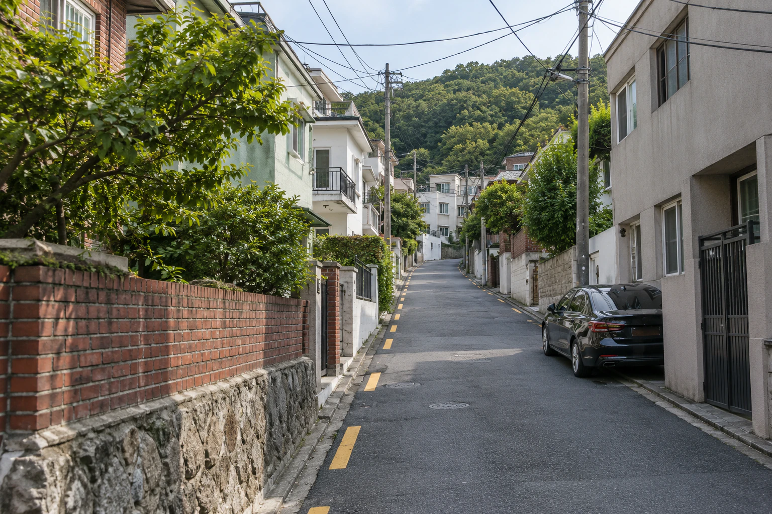
Huam-dong lies on the south-western slope of Namsan. In a 2021 interview, architect Lee Jun-hyung described Huam-dong’s mix of older houses, low-rise residential buildings, small apartment blocks and alleys, and spoke about spreading the functions of a home — kitchen, study, living room — across several spaces in the neighbourhood. The way of seeing this neighbourhood — not as a trendy backstreet but as somewhere to read, eat and stay a while — comes from that interview.
Time to choose a dessert
Lulu initially has a simple finish in mind: sit down somewhere for a drink. Maya shows Lulu the listing for Musim, a seasonal dessert bar in Huam-dong (Visit Seoul, August 2026). The changing menu catches her attention. “Could we leave time to choose a dessert, rather than just stop for a drink?”
Lulu agrees to make time for dessert. They will choose from the menu on the day. Maya is looking forward to seeing what is available and deciding together.
Lulu puts the camera in her bag and looks at the menu with Maya. Check what is available on the day you visit. The address, opening hours and verification details are in Know before you go.
“Know what today’s best shot was?” Lulu asks. “You at the observatory, looking back and laughing.” Maya looks for it on Lulu’s camera.
A half-day plan for Namsan and Huam-dong
Below is a half-day plan you can take into your own day. On a day that includes Musim, check the bar’s own notice for that day first; the walking times from the map do not include standing at the viewpoints, choosing photographs or sitting in the bar, so leave room for that when you set your start time.
| Order | Where | What | Sources · scope |
|---|---|---|---|
| 1 | Namsan Library bus stop — 03-168 | If you come by bus 402 or 405, get off at the Namsan Library stop (03-168, toward Huam Mineral Spring). This plan’s walking starts from that stop. Namsan Library (109 Sowol-ro, Huam-dong), official directions: buses 402 and 405 — Seoul Station Exit 9-1 → 402, Hoehyeon Station (Line 4) Exit 5 → 402 or 405 | about 2 minutes on foot (128 m) from the Namsan Library bus stop (03-168, toward Huam Mineral Spring) to the Sowol Garden entrance. The map route includes a pedestrian crossing over Sowol-ro |
| 2 | Sowol Garden (north entrance) | The boardwalk begins. From the library side, the trail generally heads uphill towards the south entrance | From Sowol Garden (north entrance, beside Namsan Library) the trail passes, in order, Wind Bridge → Sky Bridge → Cherry Observatory → Sunset Observatory → Rock Rest Area → Pine Rest Area (south entrance side, the southern loop road) |
| 3 | Wind Bridge | Walk with the metasequoia grove in view | the Wind Bridge's view of the metasequoia grove and the city (city guide) |
| 4 | Sunset Observatory | Take in the open view, compare it with the trail photograph you saw earlier, and choose the background for the next photo | the Sunset Observatory's glass fence and open, floating-in-air view (city guide) |
| 5 | Pine Rest Area | Forest air and a view of the tower | The city introduces the Pine Rest Area as a spot for forest bathing and a view of N Seoul Tower |
| 6 | South entrance (Health Garden, the southern loop road) | End of the boardwalk. Head out toward the loop road | The south entrance is the Health Garden beside the southern loop road, on the Namsan Fitness Park side (city location map: the Sky Forest Trail runs 1.45 km from Namsan Library to the southern loop road). At the south end the trail connects by a short crossing to the pedestrian safety deck along the southern loop road, about 0.5 km (citizen reporter’s visit, November 2025) |
| 7 | Musim — a dessert bar in Huam-dong | “Time to choose a dessert.” From the south entrance: about 23 minutes on foot (1.6 km) from the Health Garden entrance of the Sky Forest Trail to Musim in Huam-dong. The map route comes back along the loop road toward the Sowol Garden entrance before dropping into the residential streets of Huam-dong (find the walking route again on Kakao Map). This stretch is not presented as an accessible, step-free route | 4 Huam-ro 13-gil, Yongsan-gu, Seoul (Huam-dong) · Mon–Fri 12:00–18:00 · Sat 11:30–19:30 · Sun 11:30–19:00 (tourism listing, August 2026). Walking distance and time are a TMAP walking-route estimate |
The summit, tower admission and the cable car are not in this table. The tower operator gives its own note on reaching the summit: about 30 minutes on foot from the southern loop road entrance in front of Namsan Library to Palgakjeong Pavilion (tower operator).
(※ This article includes staged images created with AI.)
Before you go
The trail’s layout, length, opening date and the order of its points come from the Seoul Metropolitan Government’s official notice, with its photographs and location map. Access to Namsan Library comes from the library’s official directions. The address and opening hours of the dessert bar in Huam-dong come from the official Seoul tourism listing. The walking time within the trail and the crossing at its southern end draw on a citizen reporter’s visit. The distances and times from the bus stop to Sowol Garden, and from the Health Garden to Musim, are estimates from TMAP’s pedestrian routing. The character scenes and comparison images are editorial reconstructions, not evidence of an actual visit or photo shoot.
- The city describes the boardwalk as an accessible path with a gentle slope. That applies to this boardwalk section only. The loop road beyond the south entrance, the summit and the streets of Huam-dong are another matter.
- The walking time on the trail is a single visit record — about 30 minutes at a slow pace.
- The dessert bar’s opening hours are those in the Visit Seoul listing of August 2026. On a day that includes Musim, check that day’s notice first.
- In the residential streets, keep doorways and passages clear and avoid photographing residents who would rather not be photographed.
- An early April 2026 citizen report mentions azaleas and forsythia. An early November 2025 report mentions autumn leaves.
- On a day you want the sunset, check that day’s sunset time and decide when to reach the observatory.
- The Namsan loop bus 01A/01B uses a separate stop (03347). This plan starts on foot from the Namsan Library · Yongsan Library stop (03-168).

